Assessment tool for authenticating scientific results
With the changing environment comes different kinds of extreme weather all around the globe. In Finland, we don’t get floods or tornadoes, but our forest ecosystems take heavy damage from strong winds. We were part of a team that took the challenge to analyze those damages.

Tuulituhohaukka, loosely translated into “Wind damage detector”, is a project where we built an analyzing tool for Finnish Meteorological Institute. FMI had developed an algorithm to assess where the risk of heavy wind damages was the greatest, and now they needed a tool to assess if the algorithm was right. That is where Spatineo steps in.
From Initial Need to Project Goals (and Beyond)
Initially, the need was to create a tool that just affirms the results of the wind detector algorithm. Our team jumped right into it, and as the team was heavily interested in the topic they came up with further reaching goals for the tool than initially thought. Why just affirm the results, when we could do so much more? Making in-depth comparisons and showing the time series of the data is something that could be done with these kinds of tools.
Technicalities
The whole software was developed to be run on a browser from scratch. An easily accessible and smoothly running application that would still be able to display unlimited amounts of variations of the data available.
We started from the initial design and quickly worked towards starting the frontend development. Miska & Isabel worked with the backend, as Pauli started to get going with the front.
The development of the frontend was conducted in various steps.
The initial designs were drawn in Figma. For the UI library Material UI was chosen as it provides plenty of ready to use components and icons that work hand in hand with React.
For the implementation of the application React, TypeScript and Redux were used. The first step was to design the initial state of the application and create the corresponding reducer and actions for changing the state. The UI part of the application consisted of two types of React components: reusable components and so-called ‘views’. In the views, the reusable components would be used to piece together the user interface.
The core of the application, the map component was created using OpenLayers, an open-source JavaScript library. OpenLayers does not have an ‘out of the box’ React implementation, but with the use of refs and React hooks, such as useEffect, the map slipped to its place and works seamlessly with the rest of the application.
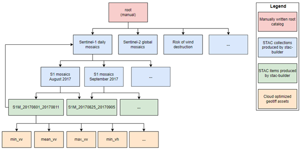
One of the core backend components of Tuulituhohaukka was the SpatioTemporal Asset Catalog (STAC). STAC is an open specification for exposing collections of spatial-temporal data. The STAC builder developed in this project produces a hierarchical STAC catalog whose structure allows efficient use of satellite image products in the browser application.
Read more: How to utilize STAC to load satellite images faster in web applications?
The catalog is in practice a set of JSON files that are stored on a network resource from which the application that utilizes the catalog can download the catalog one file at a time using HTTP requests. The files refer to each other using links, so the application that utilizes the catalog only needs to know the location of the root directory in advance. Thanks to the hierarchical structure and the links between files, the application doesn’t need to scan through all existing assets but can target the search efficiently. The importance of this efficiency becomes remarkable when the amount of assets grows. In the case of Tuulituhohaukka, we have several new assets forming every day, as new satellite image products are generated daily. The STAC builder rebuilds the catalog daily to include these new assets in the catalog.

The big picture behind the whole application was that once wind causes damages all over Finland people could check directly from the application if their properties were affected. The minimum viable product we build is still far from this goal, but we’ve already started working with new features in a continuation project. Maybe in the future Finnish Meteorological Institute could just refer to the Tuulituhohaukka application when people start calling about potential heavy wind damages?
Right now Tuulituhohaukka is utilized by scientists at FMI, Aalto university and ET forestry services and the feedback from the application has been good. Mikko Strahlendorff who works as a Space Adviser at FMI described Tuulituhohaukka like this:
“Tuulituhohaukka enhances the implementation of the Forest Act related to the wind damage caused by storms. Forest use declarations can be made earlier and more efficiently when the remote sensing analysis is done quickly and automatically via Tuulituhohaukka.”
Spatineo has already begun the next steps on the development of Tuulituhohaukka. We are eager to get the new version of the product to FMI’s scientists to assist them even further! Stay tuned for more updates on this interesting project in the future as well.