The strategic goal of the National Land Survey of Finland (NLS) is to be an active contributor to ecosystems and networks and to deliver high-quality and secure services to customers.
In the property transaction ecosystem, NLS has developed a business digital service chain and implemented Data APIs.
The Property Transaction Service is an open service where almost all contracts and applications for the transfer of real estate can be made digitally. The service allows, among other things, to complete an application for registration of ownership and to electronically sign a bill of sale. For professional users, such as municipalities, some companies (service providers) offer an interface-based drafting service for more versatile and flexible use.
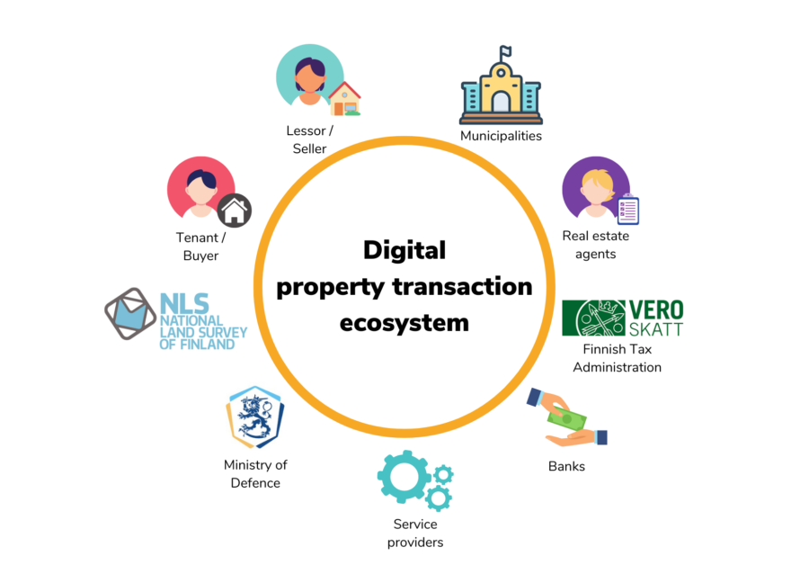
The aim of NLS is to make data flow as smoothly as possible through structured APIs. This will enable a seamless and secure digital property transaction ecosystem, involving not only NLS but also real estate agents, banks, tax authorities, municipalities and citizens.
The municipalities pose a challenge, as many of them have not yet taken into use the Property Transaction Service. Municipalities could benefit greatly from the implementation of a digital property transaction process for the sale and purchase of real estate and land leases. There is potential, as for example thousands of land lease contracts concluded by municipalities are entered into the registration register of the NLS’s title and mortgage register every year.

The views of municipalities on the usage of the Property Transaction Service were explored with interviews
The aim of the survey conducted by Spatineo was to identify the potential and attitudes of municipalities to adopt digital property transaction services in order to make them better users of the Data API in the future. In addition, we mapped the benefits that municipalities receive from using the Property Transaction Service.
The objectives of the project were:
- To identify how municipalities can benefit from NLS’s Property Transaction Service and the drafting services for real estate exchange and land leases.
- To find out how activities in municipalities are affected by the Property Transaction Service.
- To identify the capacity of different municipalities to leverage the NLS’s interface services. What factors are preventing or slowing down implementation?
- To find out the number of real estate transactions and land leases concluded by municipalities each year.
The survey was carried out by interviewing municipalities across Finland, which varied in size, type, and demographic category. The municipalities were selected so that views of both municipalities that already use the Property Transaction Service and of municipalities that do not use the service were represented. In addition to the municipalities, we interviewed three service providers as well as representatives of the NLS and the Association of Finnish Municipalities to find out their views on digital property transfer in municipalities.
Based on the interviews, case descriptions and related findings were formulated for different types of municipalities. The case descriptions highlighted the problems and barriers that prevent the municipalities from utilizing the services, how they were overcome, and the benefits of using the services. We also highlighted what have been the key factors for successful introduction of the Property Transaction Service.
In addition to the case studies, we explored the service providers’ perceptions of municipalities as customers and the service providers’ suggestions for improvements to the Property Transaction Service. Finally, we summarized general suggestions for improvements to the Property Transaction Service and its communication based on the information gathered in the project. The National Land Survey of Finland can use the results of the project to develop the Property Transaction Service and the communication about the service.
Multiple benefits for municipalities from the use of the Property Transaction Service
The survey found that municipalities perceive a wide range of benefits from the use of digital property transfer services. These benefits include savings in time, costs, and the environment, the possibility to work independently of time and place, and process-related benefits.
- Time and costs are saved by not needing to physically meet customers to sign transactions. This can save around 1-2 weeks of working time per year (with around 70 contracts per year). In addition, a transaction confirmor is not necessary when signing the bill of sale using the Property Transaction Service.
- The environment is saved as the whole process is electronic and there is no need to print or send paper forms back and forth. There are also savings on travel emissions.
- The work is independent of time and place, making the signing of contracts flexible. This has been particularly useful during the pandemic.
- There are many process-related benefits. With the Property Transaction Service, the mortgage process starts automatically. The archivable PDF from the service can be stored directly in the municipality’s own electronic archive and distributed forward. The possibility of errors is reduced thanks to automatic checks. In addition, the whole process related to property transaction is significantly accelerated.
Of the interviewed municipalities, those who use the Property Transaction Service were satisfied with the digital approach. The interviews showed that benefits can be achieved even with a surprisingly small number of contracts: if there were more than about 15 transactions per year, the municipality would benefit from using the digital service. In other words, even municipalities with a relatively low number of property transactions would benefit from using the service.
The main barriers to the introduction of the Property Transaction Service were low numbers of property transactions in the municipality or possible process changes in the municipality that the use of the service might require. Municipalities’ perspectives should be better reflected in the communication and a clear roadmap for the take-up of the service could be developed, describing the progress of the implementation process in the municipality.
NLS has used the results of the survey to ease the take-up of the service and improve the user experience
The results of the project generated development ideas that the National Land Survey will address in line with its own development model.
The development proposals relating to communication have already been considered. The terminology related to the Property Transaction Service has been harmonized and the content of NLS’s website has been updated. This will make it easier to grasp the service and the measures needed for its take-up. The perceived benefits of using the service, as highlighted in the study, will now also be taken into account when NLS communicates issues related to digital property transactions to municipalities.
In addition, NLS intends to work with service providers on development proposals to enable them to better serve municipalities as customers in the future. Often the service provider is the first contact of the municipality with the Property Transaction Service, so the role of the service provider in promoting the take-up of services is key.
The usage of digital services benefit both customers and the NLS
The wider usage of digital property transaction services will benefit municipalities, their customers such as citizens and businesses, and the NLS itself. The use of digital services can save time and money for municipalities, customers, and the NLS. In addition, using digital services saves the environment.
In the best case, information can flow between systems and people, saving extra work and reducing the chance of errors in the process. For municipalities, the greatest benefits of digital property transfer services are achieved when the service becomes a natural and functional part of the municipality’s internal processes.
-
New employee Mikko Ehnqvist
 New Employee Mikko Ehnqvist Hi! My name is Mikko, and I joined Spatineo in the spring of 2024. Transitioning to this innovative Finnish software company from a 20-year career in sales—most recently in the music industry and international business—has been an adventure. My experience in global sales, particularly in the […]
 -
How Modern Analytics Tools Improve Open Data Services
 Modern analytics tools can illuminate how geospatial APIs are used. They can reveal which services are most popular, what data is acquired through the API, the geographical areas of interest for those requests, and the origin of these requests. Additionally, they can monitor service availability, track downtimes, and identify performance […]
 -
Spatineo Building NATO Standards Compliant Metadata Capability for the Finnish Defence Forces
 Ensuring good and efficient geospatial data management is crucial for successful training, planning and operations in the defence sector. The ability of NATO members to exchange geo-information in a secure and standards compliant way is key to successful and timely collaboration and building cross-national operational capability. Spatineo continued successful collaboration […]
 -
New Age of Data Security: AI’s Role in Enhancing FTIA’s Digital Twins’ Cybersecurity
 Spatineo proudly facilitated the Finnish Transport Infrastructure Agency’s (FTIA) workshop, focusing on the future of digital twins and information security. The workshop aimed to innovate AI-based solutions to enhance the cybersecurity of digital twins. Leveraging Spatineo’s expertise in digital infrastructure and data flows, we explored FTIA’s innovative plans for digital […]
 -
Spatineo and Elenia Join Forces to Create a Groundbreaking Digital Service: Capacity Map
 Spatineo developed an interactive electrical grid Capacity Map to simplify communication between Elenia, their project developers and customers.
 -
Exciting News: Spatineo Inc. Awarded NRCan Tender for Geospatial Web Harvester Development and Operations
 We are thrilled to announce that Spatineo Inc. has been awarded both Stream 1 and Stream 2 of the tender by Natural Resources Canada (NRCan) for developing and operating the “Geospatial Web Harvester Development and Operations” project. The contract value is CAD 213 570.00. We are happy to continue working […]

Want to stay updated?
