Demand for digital, reusable and harmonised information about the built environment is growing fast. Realising efficient, well-managed, transparent and secure processes and e-services for land use decisions, building permissions and building management as well as various Digital Twin concepts require interoperable and versatile underlying data models. National level data harmonisation and efficient data management solutions are required to support governance transparency, digital democracy and co-creation as well as minimising the climate impact of urban planning.
The Department of the Built Environment of the Finnish Ministry of the Environment is leading a development program starting in 2020 for creating a new national-level information system for collecting and managing built environment datasets of national importance. This ambitious project goes hand-in-hand with legislative reforms aiming at complete digitalisation of the built environment and construction in Finland. The reformed Finnish Land Use and Building Act together with specific legislation for the platform and the registry are expected to come into effect in 2022. New harmonised data models based on international standards play a key part in enabling information flow through the entire planning and construction lifecycles starting from the initial land use development plans, supporting the building planning and construction and maintenance processes, and ending in building demolition and material reuse.
Spatineo has helped the Ministry of Environment in two related projects related to the digitalisation of land use planning in Finland: Within the “PTA Maankäyttöpäätökset” project, we were involved in a work package “Kuntapilotti” for designing and testing how digital, model based spatial planning could be implemented in the Finnish Municipalities. Our role as validating consults together with our consortium partner Paikkatietokonsultit was to help the Ministry experts in the technical details of the procurement and evaluation the results of this pilot project in 2017-19. Additionally our AWS experts implemented an OGC Web Feature Service (WFS) API to demonstrate publishing the pilot datasets using the Continuous Deployment methodology. Finally, we produced a video presentation summarising the key results of the project for the Ministry of Environment.
This work started in Kuntapilotti was continued in the “Tulevaisuuden maankäyttöpäätökset” project during 2019. We had an even more active role in this work as a member of a very talented consulting consortium with Ramboll, Ubigu and Navinova. The first action for our collaborative minds in the “Tulevaisuuden maankäyttöpäätökset” project was to plan a strategic roadmap of the activities to move into a fully digital spatial planning and management of building permissions and other land use decisions by the year 2030.
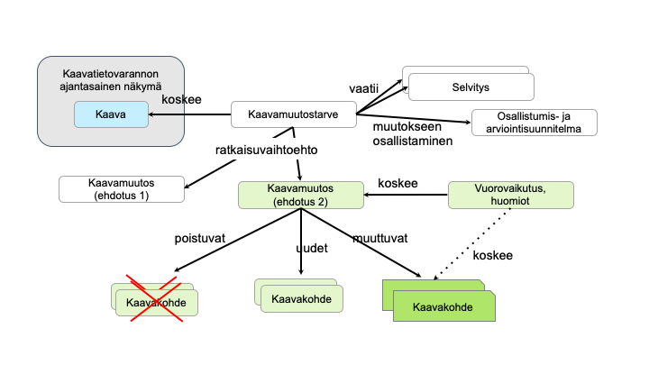
The latter part of the project was dedicated to tacking some of the commonly identified top priority activities on the roadmap, including our contributions in the documented goal state of the built environment management enterprise architecture, a novel data model for spatial planning related concepts and benefit analysis of the digitalisation of the built environment in Finland.
Our collaboration with the Finnish Ministry of Environment in designing the upcoming digital revolution of information flows related to the built environment been really interesting and exciting, and we are eager to continue working on this project in the future. Balancing between a perfect, forward-looking technical vision and realistic estimations of the changes that can be achieved in the Finnish built environment ecosystem during the upcoming years is not trivial. But then again, solving the non-trivial is what we do everyday.


