How much are Open Data APIs used for retrieving information related to critical infrastructure objects? Which datasets, user groups, and origin countries?
What kind of trends and anomalies can be found in non-domestic Open Data usage coinciding with particular geopolitical or national events?
In many cases, Open Data providers don’t have enough knowledge on how much their datasets are used and by whom. To keep the Open Data policies working as intended, the proper methods and tools are needed to analyse the use of Open Data via public APIs effectively. Organisations responsible for the data and APIs must be able to detect unintended and unwanted API use. With this information, data providers can make timely adjustments to the provided data and access it as necessary, ensuring the sustainability of Open Data flows.
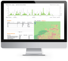
Information describing the critical infrastructure objects, such as bridges, harbours, utility networks, or water towers, is usually not provided as Open Data. Still, many datasets offer beneficial information on the surroundings of these objects. Spatineo has developed a method for automatically detecting and analyzing likely reconnaissance of the surroundings of known critical infrastructure objects based on geospatial analysis of API metadata and API web server access logs.
The analysis method has been proven to work in real customer cases and to provide answers to research questions, considering likely Open Data API reconnaissance on a national level. It has been applied in projects with more than two years of web server access logs from hundreds of individual APIs, comprising tens of billions of log entries.
Below you can download a publication from Ilkka Rinne, Sanna Hautala, Suvi-Tuulia Haakana, Miska Kauppinen, Sampo Savolainen, Riitta Vaniala (Spatineo Oy) that was initially presented at the NATO Science and Technology Organization Symposium (ICMCIS) organized by the Information Systems Technology (IST) Panel, IST-205-RSY – the ICMCIS, held in Koblenz, Germany, 23-24 April 2024.

.jpg?width=50&name=Spatineo%20-%20JooWorks%20-%20Henkil%C3%B6kuvat0023%20(1).jpg)
.png?height=200&name=Can%20Blog%20Featured%20image%20(1).png)